
Southfield Street Directory Walkthrough
A street search works best as an address trail, not as a claim that one database names every person at every door. Start with the physical parcel and record its PIN, legal description, and the way the address is written. The county parcel result can identify the owner of record and show whether the tax notice goes somewhere else. Deed records then date an ownership change. A historical directory can add a publisher-collected occupant clue for a particular year. Michigan voter material has its own narrow official route and is not a public block-browsing tool.
- Verify the postal form of the Southfield address, then search Oakland County Property Gateway by the address or PIN. Save the PIN and legal description before comparing names.
- Open the parcel on the map, pan along the street, and click nearby parcels one at a time. This identifies land parcels, not a complete household list.
- Use the PIN or legal description in the Oakland County Super Index to locate the latest recorded deed. Note each grantee, grantor, recording date, and document number.
- Ask Southfield Building or Planning for a defined permit or planning record when the project and date range are known. BS&A is the city route for applications and inspections.
- For an earlier address, check Bresser or Polk street pages and then verify the surname in an alphabetical directory or census record for the same period.
The result is a dated record trail. It may show that an owner changed, a construction project occurred, or a directory publisher listed a head of household. It does not prove that every named person still lives there.
Southfield Street Directory Property Gateway
Oakland County Property Gateway is the principal parcel starting point for a Southfield street directory search. Its search bar accepts either a property address or a PIN and requires at least five characters. The portal also supports partial street text, percent wildcards, comma-separated PINs, and map clicks. Those choices make it practical to gather candidate parcels on a long road without guessing a full address. Portal data comes from multiple municipalities, so classification and update timing can differ from one local assessor to another.
Use the official Property Gateway search to see the county’s address and PIN entry screen before entering a street or parcel number.
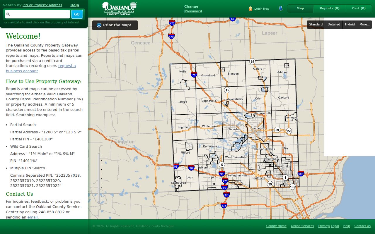
After a match, use the parcel map and the displayed property identifiers to keep similar street names and nearby municipalities separate. Reports and printable maps may require a cart, account authorization, or payment, while basic map and search features are available through the portal.
| Gateway field or tool | Entry type | Southfield use |
|---|---|---|
| Search by PIN or Property Address | Required text, five-character minimum | Start with the known address or stable parcel identifier. |
| Partial address | Optional text | Use a beginning such as “1200 S” to return candidate street addresses. |
| Percent wildcard | Optional text | Broaden a street search with patterns such as “1% Main.” |
| Partial or multiple PINs | Optional text | Compare a partial PIN or comma-separated parcel list along a block. |
| Map click and reports | Map and cart controls | Open a parcel from the map, then choose available map or report products. |
Southfield Street Records by Address
The same address can appear in several Southfield record systems, but the fields mean different things. A property card may connect an owner to a parcel. The Register of Deeds indexes the transfer parties and legal description. A city permit can place an applicant or contractor at a project date. A directory reports what its publisher collected for a particular edition. The table below keeps those roles distinct and shows why a PIN is more dependable than a street number when a parcel has been split, converted to a condominium, or described under an older lot number.
| Address record | Southfield keeper | What it can establish | Access channel |
|---|---|---|---|
| Parcel and property report | Oakland County Property Gateway and local assessor data | PIN, owner, situs, mailing address, tax status, exemptions, map, and legal description where supplied. | Online search and map; some reports are paid. |
| Deed and land index | Oakland County Clerk/Register of Deeds | Transfer parties, recording date, document number, legal description, and recorded-property continuity. | Super Index online from 1964; counter and copy route for older material. |
| Tract and plat files | Oakland County Tract Index | Lot, block, subdivision, condominium, or metes-and-bounds path when an address is weak. | Pontiac counter, staff help, binders, and map products. |
| Permit or planning file | Southfield Building and Planning | Project, inspection, applicant, contractor, and timing where the public record permits release. | BS&A, department counter, or a specific FOIA request. |
| Historic street directory | Library collections | Publisher-listed address, head of household, phone, owner or renter mark, and movement clues by volume. | Library, licensed database, or digitized collection when available. |
| Qualified Voter File request | Michigan Department of State and local clerks | Authorized public voter fields within a defined geography, subject to required redactions. | Official request form or individual voter lookup, not street-wide browsing. |
For older land records, Oakland County says online copies in Super Index begin January 1, 1964, apart from subdivision plat maps. Manual books, retention material, and archival holdings can be needed before that point. The Tract Index can search by PIN, subdivision lot, condominium unit, or metes-and-bounds description, making it the practical fallback when a historic deed omits the current street number.
For a current ownership alert, Oakland County also offers its free Property Records Notification service. It is most precise when tied to the ten-digit PIN. An alert can help a property owner notice a newly recorded document, but it is not a title search and does not replace checking the actual recorded image and its legal description.
Southfield Street Directory Address Terms
Reading a parcel result carefully prevents a common mistake in street research. The physical place and the tax-notice destination are not interchangeable. An exemption flag can be useful context, yet it does not create a roster of everyone at the address. A legal description also matters because it can survive when a street number changes or when a historical volume uses an abbreviation. Keep the original wording from each source in your notes and compare the date of the record before drawing a conclusion.
- Parcel or PIN
- The county property identifier, often shown in a ten-digit style such as xx-xx-xxx-xxx. Dashes may be omitted. It is usually steadier than a street number.
- Situs address
- The physical location of the Southfield parcel. It is the address used to match the map, tax information, and legal-description trail.
- Mailing address
- The place where an owner or taxpayer receives notices. It may be outside Southfield and is not proof that the owner lives at the parcel.
- Plat
- A recorded subdivision map that ties lots and blocks to a development. It helps bridge a newer street address to an older legal description.
- Criss-cross directory
- A directory arranged by street and house number rather than surname. Bresser volumes can place a listed head of household in address order.
When a street entry seems to shift from one number to another, compare the PIN, lot and block, nearby intersections, and the plat before assuming a move. Southfield’s road grid is organized around Mile Roads and north-south roads such as Evergreen, Greenfield, Lahser, Telegraph, Southfield, and Inkster. The city grew from Southfield Township and incorporated in 1958, so older material can use a township or neighboring postal label.
Southfield Street Permits and Plats
Building and planning records add timing to a street-level property history. Southfield Building uses BS&A for permit applications and inspection requests, while Planning uses that route for site plans, fences, landscaping, tree removal, zoning letters, rezoning, special land use, and street or alley vacations. The publicly visible result fields and historical cutoff were not confirmed during research. Ask for the address, project type, and date window rather than making a broad request for every document.
The county’s plat route can answer a different question: how did the present address connect to the recorded land? Oakland directions point researchers to PLAT Records, then Search Additional Criteria, the county and subdivision name, a record number, and attachments. The Tract Index also holds permanent plats and map products. This matters on streets near Lathrup Village or other boundary quirks, where a Southfield postal label alone does not establish the municipal parcel.
Southfield’s Building Department offers online applications and inspection requests through BS&A, and its public counter has separate access. A written request under the Michigan Freedom of Information Act should identify the record category and dates. Michigan FOIA normally calls for a grant, denial, partial response, or one extension within five business days, but it does not turn restricted personal information into an open address list.
Southfield Street Directory History
For a past household, the Bresser and Polk collections take the street search further than a current parcel card. Bresser street pages are especially useful for address-to-head-of-household research and may include a phone number, an owner or renter notation, the first year listed, a new-arrival mark, or a move within the area. Polk street pages arrange residents and businesses by house number and can include more household detail. Neither format replaces a deed, and each volume must be checked to make sure its geography includes Southfield.
The local South Oakland County inventory located Bresser for 1978 through 1996 and Polk for 1997 through 1998. The Library of Michigan reports broader Polk holdings reaching into the late 1800s, while Detroit Burton collections have regional directories across several earlier periods. Publisher titles and coverage changed over time, so an absent address may reflect the volume’s scope rather than an empty house. Search road abbreviations, a middle initial, adjacent house numbers, and a former surname.
For family-history work, pair the closest directory issue with the federal census year. The public census endpoint is 1950. Census images can show a full enumerated household, while annual directory entries help bracket movement between census dates. If name search OCR fails, browse by enumeration district, street, neighbors, and the image itself.
Southfield Street Grid and USPS
Southfield’s north-south grid makes cross streets and Mile Roads useful checks when an older directory abbreviates a road or a current address produces several candidates. Eight through Thirteen Mile, Evergreen, Greenfield, Lahser, Telegraph, Southfield, and Inkster are durable geographic reference points. USPS by-address lookup can confirm a delivery address and ZIP, but its result does not confirm that a person or company occupies that address. Postal labels can cross municipal lines, especially near Lathrup Village, so use the Oakland PIN and municipality data for the legal parcel.
Southfield Street QVF Requests
Michigan’s Qualified Voter File has a formal request route, not a public search that lists a street. The official form permits one geographic choice, including a jurisdiction, district, school, or ward and precinct. It also offers defined voter-history selections and delivery by pickup, mail, or arranged FTP. A requester should describe the geography narrowly and ask about cost before ordering a large file. Required redactions remain in place: driver-license and state-ID numbers, month and day of birth, phone, email, signatures, last four Social Security digits, and ACP applications are not released.
Southfield Street Counter Fallbacks
When an online result stops short, use the office that holds the next record. Oakland County provides the Tract Index and public counter in Pontiac for older land material, with telephone, mail, and in-person copy routes. Southfield Building and Planning can address a defined permit or zoning file. Southfield Public Library’s Reference Desk can identify a directory, yearbook, obituary, newspaper, or local-history item before a visit. For township-era material, the Southfield Historical Society, Library of Michigan, and Archives of Michigan are more useful than repeatedly rerunning a modern address search.
Southfield Street Search Limits
A parcel record identifies land ownership, not every person behind a door. A historical directory records publisher-collected information for one edition. Michigan’s public voter materials are subject to statutory redactions, and the normal Michigan Voter Information Center is an individual status service rather than a street roster. A QVF request must use the official form and one defined geographic choice such as jurisdiction, district, school, or ward and precinct. It can never supply protected fields, ACP voter applications, ballot choices, phone numbers, email, a signature, or month and day of birth.
Utility accounts, delivery lists, DMV addresses, unlisted people, sealed case parties, and people who never owned property are outside a Southfield street directory search. The Michigan Address Confidentiality Program also protects qualifying participants through a substitute-address system. If the source has an error, contact the assessor for parcel data, the Register of Deeds for a land-index or document issue, the city clerk for voter information, or the court that owns its file.
Use address records with care. Southfield property and historical records support family history, estate research, civic curiosity, and checking a suspicious property claim. Do not use them to stalk, harass, intimidate, or harm anyone.